In a couple of earlier posts, here and here, I explained the mix of politics and Voting Rights Act issues involved in the Louisiana v. Callais case. The specific issue is whether LA engaged in unconstitutional racial gerrymandering when it enacted its current map of congressional districts.
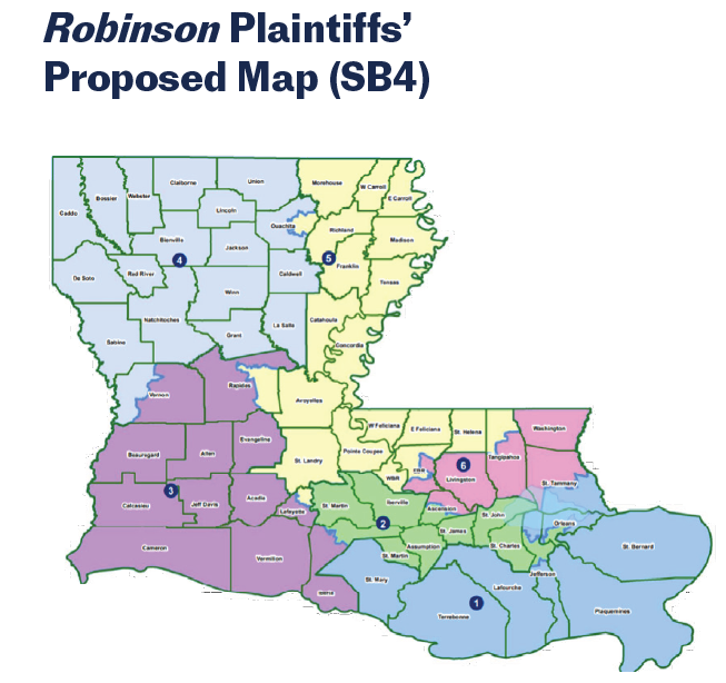
To make that earlier discussion more concrete, here are a couple of maps that illustrate the context. In an earlier stage of the litigation, plaintiffs prevailed in their claim that the VRA required a second VRA district to be drawn. The courts reached that conclusion based in part on illustrative maps the plaintiffs submitted, which showed that a reasonably configured second majority black voting-age population district could be drawn. The first map here shows one of the maps plaintiffs offered to establish that point. In that map, the second district, CD #5, is in the northeast part of the state (CD #2 is the second VRA district, a long-standing one based on New Orleans).
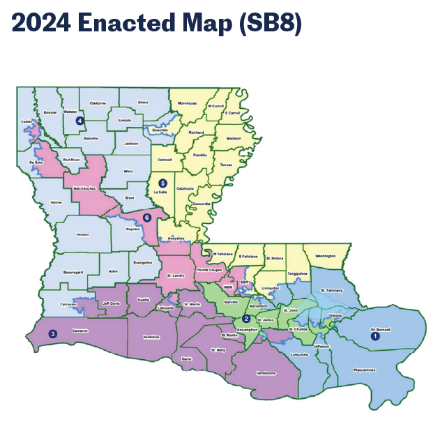
But that’s not the region in which the Republican legislature decided to draw the new, required second VRA district (the state was not legally obligated to draw the district in the region the plaintiffs had identified) . As the second map here shows, it instead created the newly designed CD #6, which is the diagonal district (in pink) that begins in the northwest part of the state and then runs southeast through the center of the state. As those earlier posts explain in more detail, one incumbent Republican was going to lose their seat once a second VRA district was created. The Republicans wanted to preserve the Republican holding the seat in the northeast part of the state, and drew CD #6 in the location and shape it has in order to sacrifice a different Republican incumbent less popular with the party leadership.
As I said in an earlier post, if the Court invalidates CD #6 in the current map, LA will still be under the obligation to draw a second VRA district (unless the Court goes well beyond that issue). While we await the Court’s decision, I thought these maps provide helpful context for understanding the case. And I like looking at redistricting maps.